


5-directional oblique capture, Distortion Correction 2.0, 49-minute flight time, free 1-year DJI Terra Pro subscription, professional geospatial mapping, surveying, construction planning, asset inspections, topographic mapping, urban 3D modeling, infrastructure inspection, environmental monitoring, disaster response. Learn about precision aerial mapping for professionals.
DJI Matrice 4E Universal Edition — Complete FAQ
What is 5-directional oblique capture and why does it matter for 3D modeling?
5-directional oblique capture means the Matrice 4E simultaneously captures images from five angles: nadir (straight down), and four oblique directions (forward, backward, left, right). This revolutionary approach captures photorealistic 3D data in a single flight that previously required multiple passes with conventional drones. For urban 3D modeling, topographic mapping, and construction planning, this means you get complete geometric coverage of buildings, terrain, and infrastructure from every angle. The result is survey-grade 3D models with unprecedented accuracy and detail, reducing flight time and costs while improving data quality.
What is Distortion Correction 2.0 and how does it improve mapping accuracy?
Distortion Correction 2.0 is DJI's advanced algorithm that automatically corrects optical and geometric distortions in aerial imagery in real-time. This ensures that every pixel in your orthomosaic and 3D models is geometrically accurate and survey-grade. For professional applications like infrastructure inspection, topographic mapping, and disaster response, this level of accuracy is critical. Distortion Correction 2.0 eliminates the need for manual post-processing corrections, saving hours of work and ensuring your data meets professional surveying standards. Your maps, models, and measurements are accurate from the moment you process them with DJI Terra Pro.
How does the 49-minute flight time benefit large survey areas?
The Matrice 4E's 49-minute flight time is the longest in its class, allowing you to cover significantly larger survey areas in a single battery cycle. For a 200-acre construction site, a 500-acre topographic survey, or a disaster response area, this extended endurance means fewer battery swaps, fewer flights, and faster project completion. You can capture comprehensive data in one mission that would require multiple flights with competing drones. This translates directly to cost savings, improved efficiency, and faster delivery of results to your clients. The extended flight time also reduces operational complexity and weather-related delays.
What is the value of the included 1-year DJI Terra Pro subscription?
DJI Terra Pro is professional-grade photogrammetry software that processes your aerial imagery into orthomosaics, 3D point clouds, and digital elevation models. Normally priced at $500+ per year, the included 1-year subscription is a $500 value included free with your Matrice 4E purchase. This software is essential for converting your raw aerial data into actionable intelligence. With Terra Pro, you can process your 5-directional oblique imagery with Distortion Correction 2.0 applied, generate survey-grade 3D models, create precise orthomosaics, and export data in industry-standard formats. You're ready to deliver professional results to your clients immediately after your first flight.
What professional use cases is the Matrice 4E ideal for?
The Matrice 4E is purpose-built for geospatial professionals across multiple industries: Surveying & Mapping professionals use it for precise topographic surveys and boundary mapping. Construction & Planning teams use it for site progress monitoring and volumetric analysis. Asset Inspection specialists use it for infrastructure assessment, power line inspection, and bridge evaluation. Urban 3D Modeling professionals use it for city planning and digital twin creation. Environmental Monitoring teams use it for land cover analysis and change detection. Disaster Response coordinators use it for rapid damage assessment and emergency planning. The combination of 5-directional oblique capture, Distortion Correction 2.0, and 49-minute flight time makes it the ideal choice for any professional application requiring survey-grade accuracy.
How does the Matrice 4E compare to previous Matrice series drones?
The Matrice 4E represents a significant leap forward in the Matrice series. Previous Matrice models offered single-direction or limited multi-directional capture; the 4E introduces true 5-directional oblique capture for complete geometric coverage. Distortion Correction 2.0 is new to the 4E, providing superior accuracy compared to earlier models. Flight time has been extended to 49 minutes, the longest in the Matrice series. The Universal Edition includes the free 1-year DJI Terra Pro subscription, eliminating the need for separate software purchases. The 4E also features improved thermal stability, better wind resistance, and enhanced reliability for professional operations. If you're upgrading from an older Matrice model, the 4E delivers dramatically better data quality, faster workflows, and lower total cost of ownership.
What regulatory considerations apply to commercial drone operations with the Matrice 4E?
Commercial drone operations are regulated by the FAA (in the US) and equivalent authorities in other countries. You'll need a Part 107 Remote Pilot Certificate to operate the Matrice 4E commercially. The drone itself is not restricted, but your operations must comply with airspace regulations, altitude limits (400 feet AGL), line-of-sight requirements, and local restrictions. For surveying and mapping work, you may need additional permits or waivers depending on your location and project scope. Professional liability insurance is highly recommended. The Matrice 4E's reliability, safety features, and professional-grade capabilities make it an excellent choice for operators who maintain proper certifications and follow all applicable regulations. Always check local regulations before conducting commercial operations.
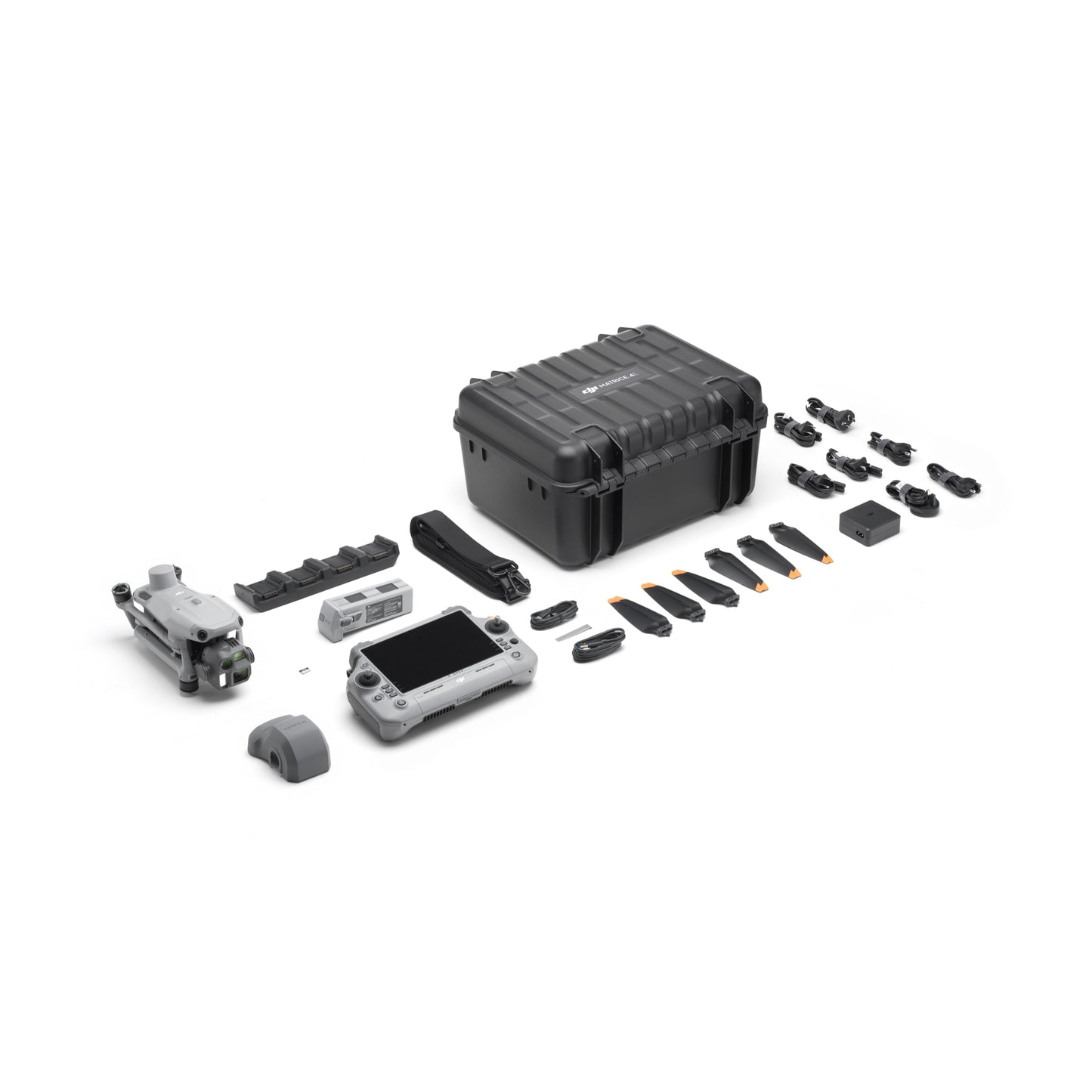
What is included in the DJI Matrice 4E Universal Edition?
The Universal Edition includes the Matrice 4E aircraft, two Intelligent Flight Batteries (for extended operations), a three-way charging hub, remote controller, all necessary cables and adapters, propellers, and comprehensive documentation. Most importantly, it includes a 1-year subscription to DJI Terra Pro (a $500+ value), professional photogrammetry software essential for processing your aerial data. The Universal Edition is designed for professionals who want everything needed to start capturing and processing survey-grade aerial data immediately. No additional software purchases required. Everything is included in the $5,099 price, making it an exceptional value for geospatial professionals.
Why is the $150 savings (from $5,249 to $5,099) significant for professionals?
The $150 savings represents exceptional value when combined with the included 1-year DJI Terra Pro subscription ($500+ value). You're getting professional-grade aerial mapping hardware plus essential software at an unbeatable price point. For geospatial professionals, this savings can be reinvested in additional batteries, accessories, or software licenses. When you factor in the extended 49-minute flight time (reducing operational costs), the 5-directional oblique capture (reducing flight missions), and Distortion Correction 2.0 (reducing post-processing time), the total value proposition is extraordinary. This is the right time to upgrade to the Matrice 4E and take advantage of this limited-time pricing.
Why Choose the DJI Matrice 4E Universal Edition? 5-Directional Oblique Capture. Distortion Correction 2.0. 49-Minute Flight Time. Free 1-Year DJI Terra Pro. $5,099.00.
The DJI Matrice 4E Universal Edition is purpose-built for geospatial professionals requiring survey-grade accuracy. 5-directional oblique capture delivers complete geometric coverage in a single flight. Distortion Correction 2.0 ensures every pixel is survey-accurate. 49-minute flight time covers larger areas with fewer missions. The included 1-year DJI Terra Pro subscription ($500+ value) provides professional photogrammetry software. Perfect for surveying, mapping, construction planning, asset inspections, topographic mapping, urban 3D modeling, infrastructure inspection, environmental monitoring, and disaster response. Geospatial professional grade at an exceptional price.
| DJI Matrice 4E Universal Edition | Standard Survey Drone | |
|---|---|---|
5-Directional Oblique Capture — simultaneous nadir + four oblique angles for complete geometric coverage vs. single direction only |
||
Distortion Correction 2.0 — real-time optical and geometric correction for survey-grade accuracy vs. no distortion correction |
||
Flight Time — 49 minutes (longest in class) covers larger areas per mission vs. 25-30 minutes requires more flights |
||
DJI Terra Pro Included — 1-year professional photogrammetry software subscription ($500+ value) included vs. not included |
||
Professional Applications — surveying, mapping, construction, inspections, topographic, urban 3D, infrastructure, environmental, disaster response vs. limited applications |
||
Construction + Inspection + Disaster Ready — purpose-built for all professional geospatial workflows vs. varies by model |
||
Exceptional Value — $5,099 from $5,249 ($150 savings) + $500 software included vs. comparable drones with fewer features at higher prices |
DJI Matrice 4E Universal Edition. 5-Directional Oblique Capture. Distortion Correction 2.0. 49-Minute Flight Time. Free 1-Year DJI Terra Pro. $5,099.00.
Purpose-built for geospatial professionals. 5-directional oblique capture delivers complete geometric coverage in a single flight. Distortion Correction 2.0 ensures survey-grade accuracy. 49-minute flight time covers larger areas with fewer missions. Free 1-year DJI Terra Pro subscription ($500+ value) included. Perfect for surveying, mapping, construction planning, asset inspections, topographic mapping, urban 3D modeling, infrastructure inspection, environmental monitoring, and disaster response. Professional-grade aerial mapping at an exceptional price.
Get Your DJI Matrice 4E for $5,099.005-Directional Oblique Capture
Distortion Correction 2.0
49-Minute Flight Time
5-Directional Oblique Capture
Distortion Correction 2.0
49-Minute Flight Time
5-Directional Oblique Capture
Distortion Correction 2.0
49-Minute Flight Time
5-Directional Oblique Capture
Distortion Correction 2.0
49-Minute Flight Time
DJI Matrice 4E Universal Edition — Professional Aerial Mapping for Geospatial Professionals — $5,099.00
The DJI Matrice 4E Universal Edition is purpose-built for geospatial professionals requiring survey-grade accuracy. 5-directional oblique capture delivers complete geometric coverage in a single flight. Distortion Correction 2.0 ensures every pixel is survey-accurate. 49-minute flight time covers larger areas with fewer missions. The included 1-year DJI Terra Pro subscription ($500+ value) provides professional photogrammetry software. Perfect for surveying, mapping, construction planning, asset inspections, topographic mapping, urban 3D modeling, infrastructure inspection, environmental monitoring, and disaster response. Geospatial professional grade at an exceptional price.
DJI Matrice 4E Universal Edition — Key Advantages
100%
5-Direction Oblique + Distortion Correction 2.0
The most accurate aerial mapping data available
100%
49-Minute Flight Time
Maximum coverage per mission, minimum battery swaps
100%
DJI Terra Pro Included
$150 off + 1-year professional mapping software at no extra cost
5-Direction Oblique + Distortion Correction 2.0: The most accurate aerial mapping data available. Simultaneous nadir and four oblique captures deliver complete geometric coverage in a single flight. Distortion Correction 2.0 ensures every pixel is survey-accurate. Perfect for urban 3D modeling, topographic mapping, and infrastructure inspection. Get photorealistic 3D models that previously required multiple passes with conventional drones. Survey-grade accuracy from the moment you process your data.
49-Minute Flight Time: Maximum coverage per mission, minimum battery swaps. The longest flight time in its class allows you to cover significantly larger survey areas in a single battery cycle. For a 200-acre construction site, a 500-acre topographic survey, or a disaster response area, this extended endurance means fewer battery swaps, fewer flights, and faster project completion. You can capture comprehensive data in one mission that would require multiple flights with competing drones. This translates directly to cost savings, improved efficiency, and faster delivery of results to your clients.
DJI Terra Pro Included: $150 off + 1-year professional mapping software at no extra cost. DJI Terra Pro is professional-grade photogrammetry software normally priced at $500+ per year. The included 1-year subscription is included free with your Matrice 4E purchase. This software is essential for converting your raw aerial data into actionable intelligence. With Terra Pro, you can process your 5-directional oblique imagery with Distortion Correction 2.0 applied, generate survey-grade 3D models, create precise orthomosaics, and export data in industry-standard formats. You're ready to deliver professional results to your clients immediately after your first flight.